


LITTLE ROCK, Ark. — 8:30 AM Update - Much of the area is experiencing drizzle this morning, resulting in wet roadways. This increases the potential for a "flash freeze" this afternoon that could result in a thin sheet of ice, ultimately causing slick spots on roadways. A flash freeze occurs when temperatures drop so rapidly that any water on the ground freezes before it can evaporate. - Skot
---
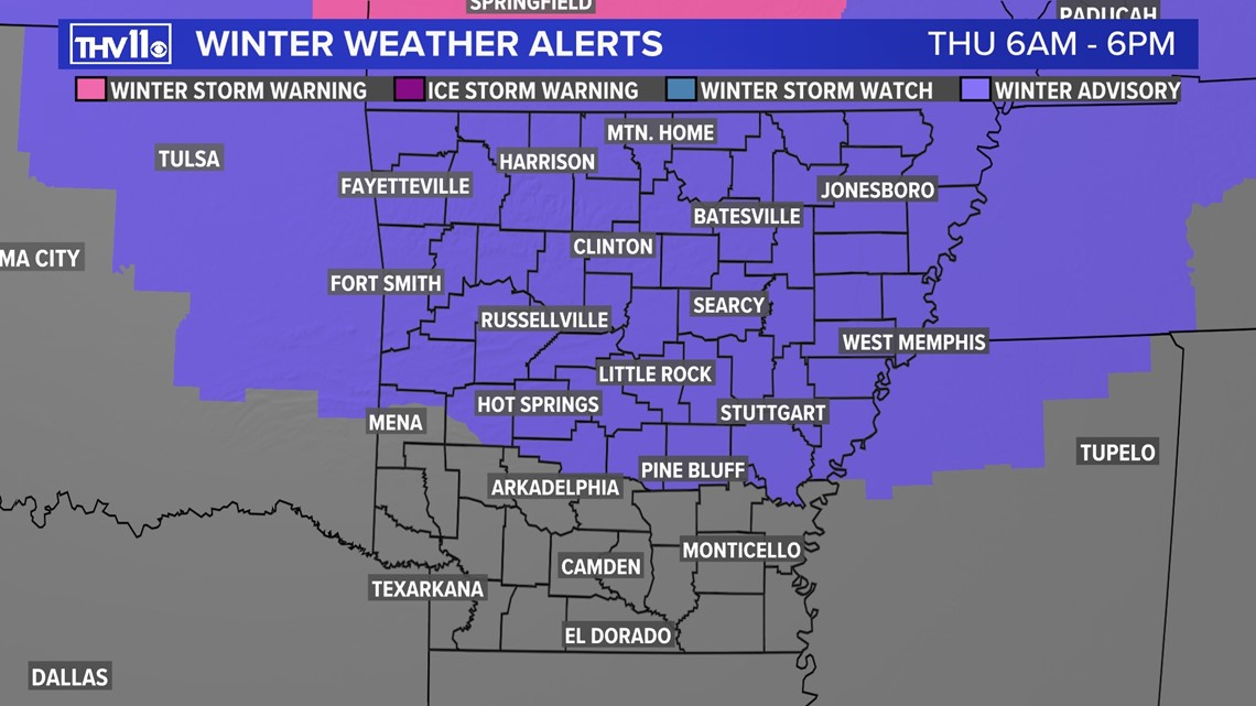
A Winter Weather Advisory has been issued for most of the state for the potential of moisture quickly freezing on roads and creating a thin layer of ice. This is known as a flash freeze. This condition is very difficult to predict because the gusty winds behind the cold front may dry out the ground before it has a chance to freeze.
However, if you can leave work early on Thursday that may be a good idea. The worst road conditions will be in North and NW AR where accumulating snow is likely and will cover the roads.
A chunk of Siberian air is taking over a large part of the country as the official start of winter begins.
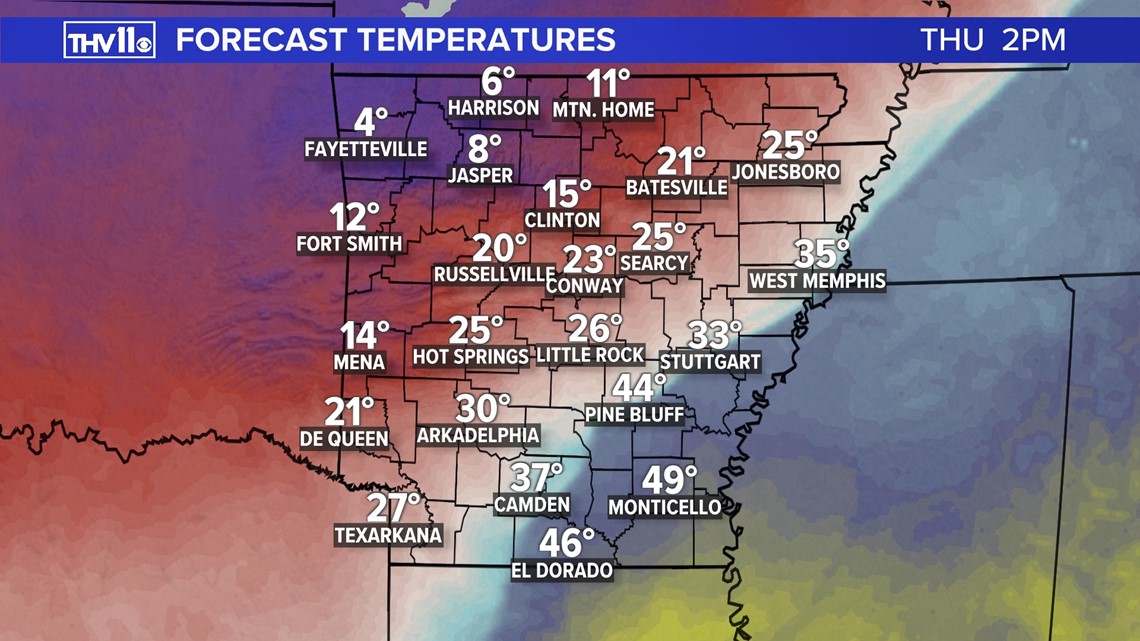
Temperatures ahead of an arctic front will rise into the 40s Thursday morning. But don't be fooled, drastic changes will take place as the front slices through the state.
Howling winds from the NNW at 30 to 40 mph will send the mercury falling into a freefall. Expect the temperatures to go from the 40s around noon in Central Arkansas, but then plummet into the 20s and 10s for the evening rush.
There will likely be a 50 degree difference in the afternoon temperatures from the southeast to the northwest part of the state.

Bitterly cold air will continue to flood into the state through Thursday night and into Friday morning.
Most locations will wake up to temperatures into the single digits and below zero Friday morning. This will be the coldest air that we have seen since snowstorm back in February 2021.
But that is only half the story, because on top of the frigid readings will be a whipping wind that will take away the heat from your body.
This is known as the wind chill and those numbers will be dangerously cold.

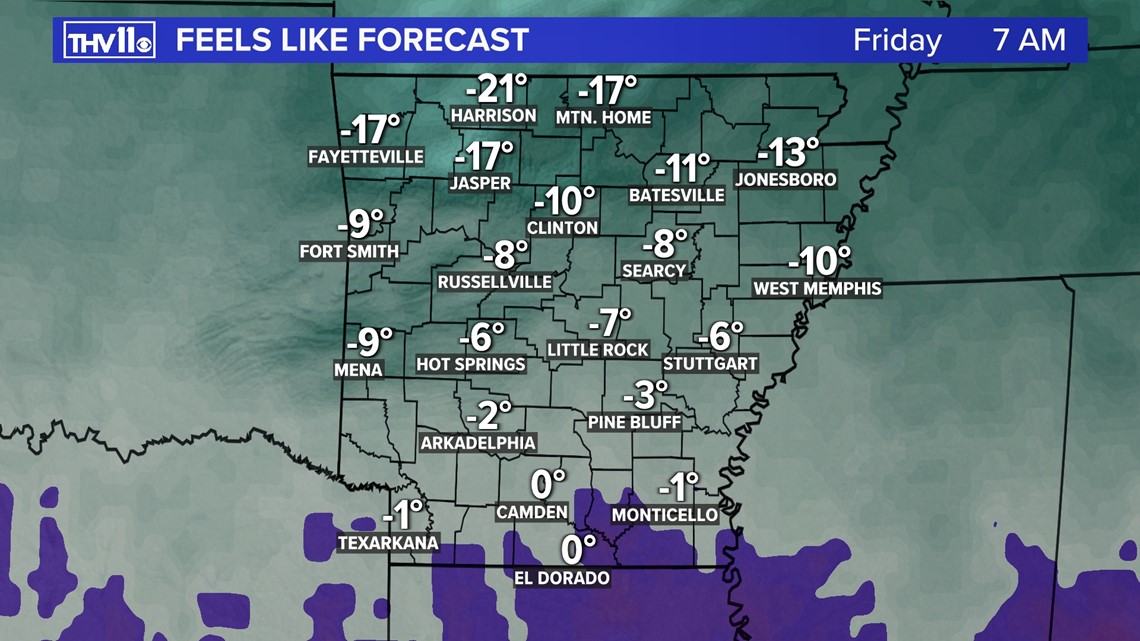
Expect a piercing and biting shock to the system. You should prepare properly by having gloves, hats, and heavy coats to keep you warm and prevent hypothermia.
Wind chill warnings and advisories have been issued for most of Arkansas. These will go in effect 6AM Thursday morning and continue through Friday morning.
This means if not properly prepared these type of conditions can cause hypothermia and frostbite.


Make sure the pets are brought inside or have a warm place to go and shelter from the cold. If they have to stay outside make sure they have fresh water.
Temperatures could will stay well below freezing from Thursday afternoon into most of Sunday, and this could lead to pipes freezing and bursting that are not insulated.


Rain will change to snow showers and flurries Thursday for 4 to 5 hours before ending by the early evening. This system does not have much moisture and is fighting dry air.
Scattered accumulation of a dusting to 1" looks possible across central AR, but many places may just see flurries fly.
The better chance of more snow and travel impacts will be in northern Arkansas and into Missouri. Here with gusty winds and snow flying, near white-out conditions will be possible along with snow covered roads.


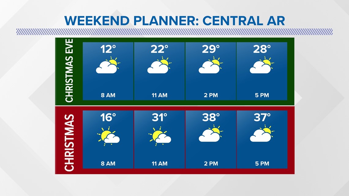
By later Thursday evening the snow will be gone. Christmas Eve into Christmas Day the weather will be quiet, but cold across the Mid-South.

Stay tuned to THV11 for the latest on our first arctic blast of the season.