

Our main focus has been on the severe weather potential for Saturday, but we can’t forget about Friday.
A marginal risk for severe weather exists. This means that a few storms could be on the strong side Friday afternoon. The timeline for this is 5 p.m. to 10 p.m. The main concern will be heavy rain that leads to flooding and a small hail threat. Light rain is expected overnight.
On Saturday, the enhanced risk area has been expanded to include all of Eastern Arkansas. The enhanced risk is a category 3 out of 5 for likelihood of seeing a severe storm.

The more east you are, the more likely you are to see a strong to severe storm.
Chief Meteorologist Ed Buckner
Here is a look at our severe weather threats for Saturday:

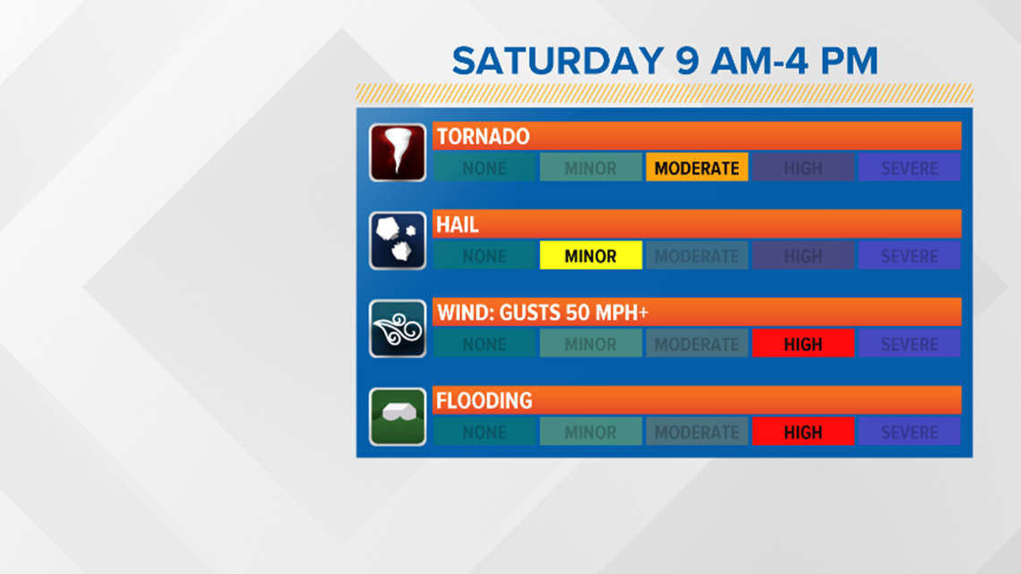
Flooding will be a main concern since it is an issue we have been dealing with for a few days. Any additional rain at this point will add to the problem.
A lot of moisture is available in the atmosphere and that will contribute to the threat of thunderstorms producing a lot of rain in a small amount of time.
Strong winds will also be a concern as the line of thunderstorms pushes through. This will mainly be monitored along the leading edge of the approaching line.
Another area to watch for would be within storms that get ahead of the line. After the thunderstorms move through, Saturday evening and into the night will be windy behind the front, with speeds of about 15 to 25 miles per hour. This could lead to down trees.
Tornado threat also exists, but it will not be widespread. For the western two-thirds of the state, this could happen if any cells go rogue ahead of the line of thunderstorms.
This is because they are not competing for the available energy out there to grow. For the eastern one-third of the state, this could happen within the line.
Remember, this is a forecast and tornadoes don’t always follow these rules. This is just where I will be monitoring unless something else catches my eye.
Hail is the more minor concern. I say this because it is less likely to see large hail from the entire line of storms moving through, but we aren’t completely ruling it out on our list of threats.
Weekend Timeline
Friday Evening:

We highlighted the southern and eastern part of the state earlier in the article for seeing thunderstorms in this area. Not all will be severe, but a few could be on the strong side with hail being the severe factor. This threat will be over by 10 p.m.
Midnight Friday into Saturday:
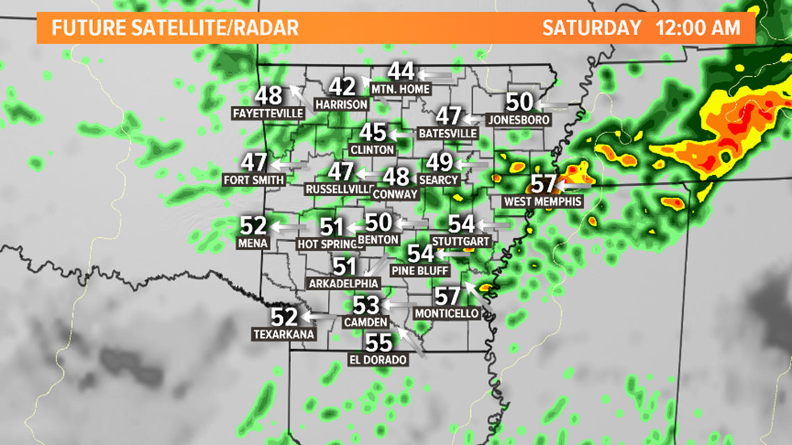
Expect clouds with light rain. The heavy rain has pushed east by this point and the strong storms to our west have not taken shape yet.
Saturday Morning:
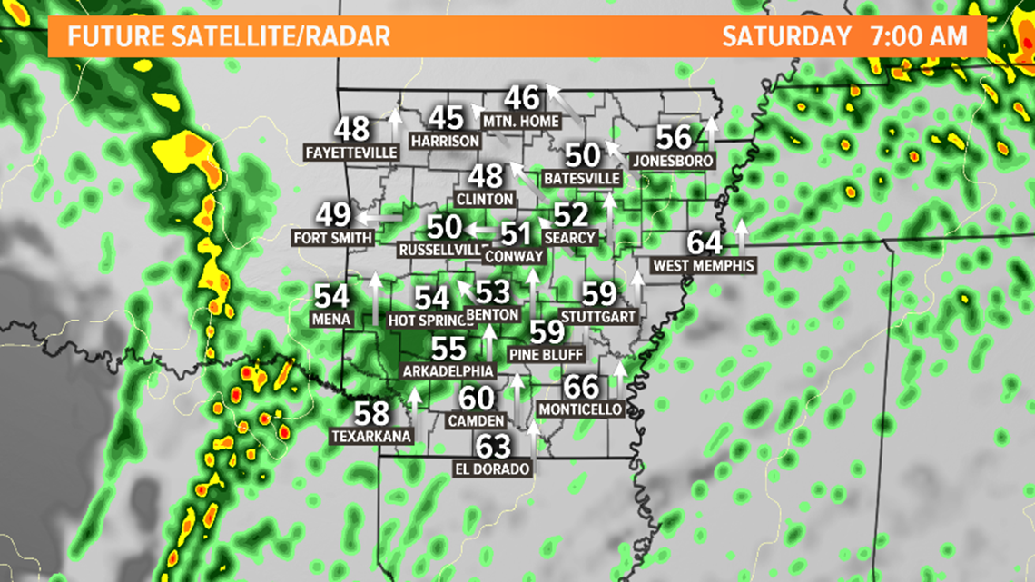
Around 7 a.m. is when thunderstorms start forming a line in eastern Oklahoma. Notice the light rain ahead of the line in Arkansas. Also notice the numbers. Those are potential temperatures and yes, they did warm through the night.
The line of storms moves in around 9 a.m. The line will move west to east.
It does become a bit unorganized (messy) when it reaches the higher terrain of western Arkansas. It will still be producing heavy rain, but tornado threat is low.
By 11 a.m., central Arkansas could already be seeing light rain. The line of thunderstorms will be moving in between 11 a.m. to 12 p.m.
Here is where we could see wind speeds increase along the leading edge. At this point, we will also be looking for supercells (rotating thunderstorms) ahead of the main line.
Saturday Afternoon:

The line of storms moves out of central Arkansas by 2 p.m.
Breezy weather to follow behind the line. After the main line passes through, look for signs of river flooding and downed trees. As the line pushes east, notice it now lines up as it approaches the area under an enhances risk. At this point, all modes of severe weather will be possible.
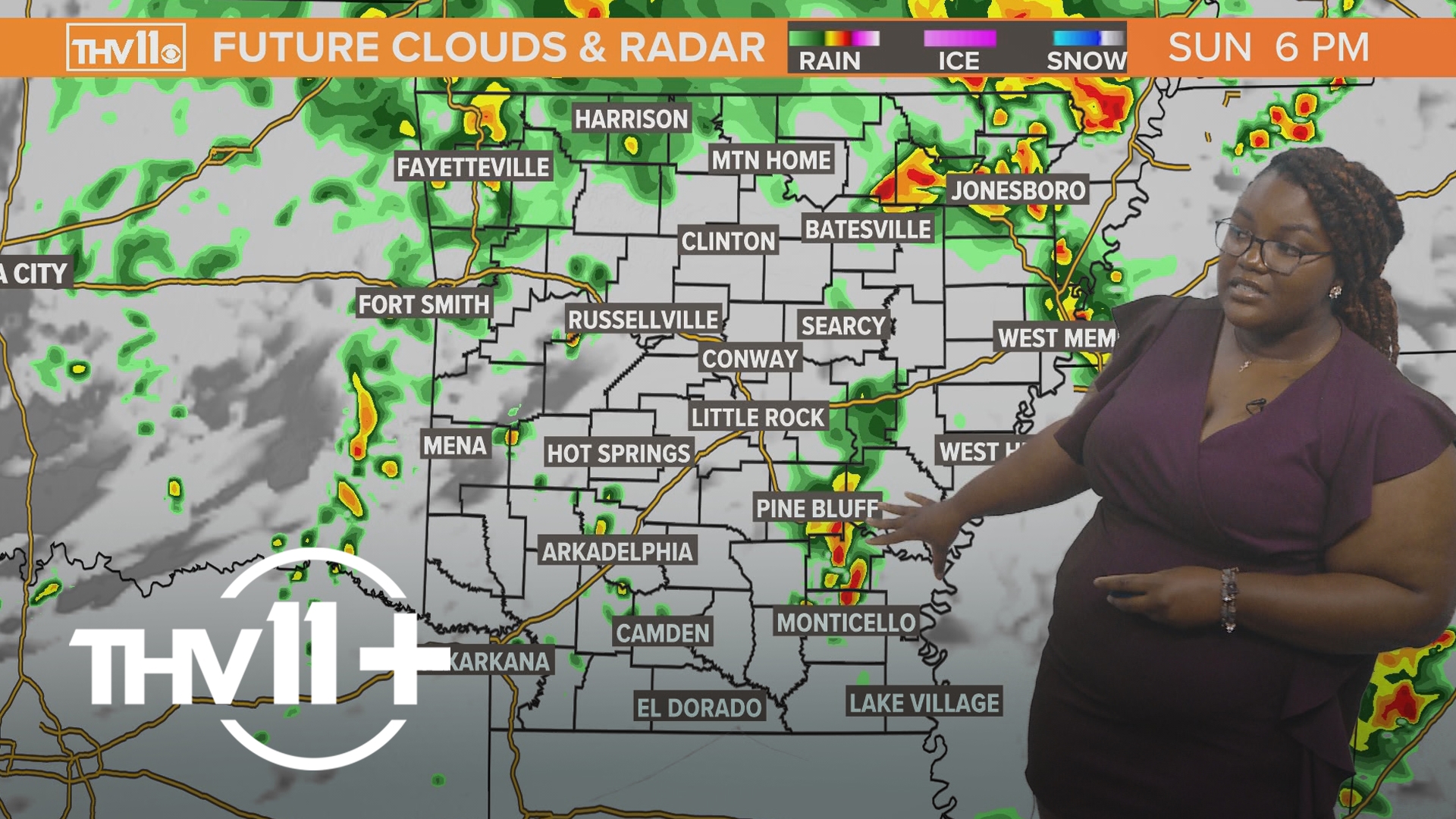
The threat of severe weather will push out by 4 to 5 p.m. This line continues to move east and strengthen. Our temperatures will drop through the evening and overnight. We will finally see sunshine on Sunday.